This site is supported by you, the reader. If you make a purchase through one of my links, I may earn a small commission. Learn more here.
Guest post by Pat Connelly from Connelly Wildlife Management
I’ve been using the OnX Hunt app since I heard Steve Rinella and the Meateater crew talking about it. I now use it every day, on the trapline and off. These are some of the ways I use the app as well as some ideas I’ve had for potentials uses. I also want to mention some features that could use some slight tweaks.
Staying Legal
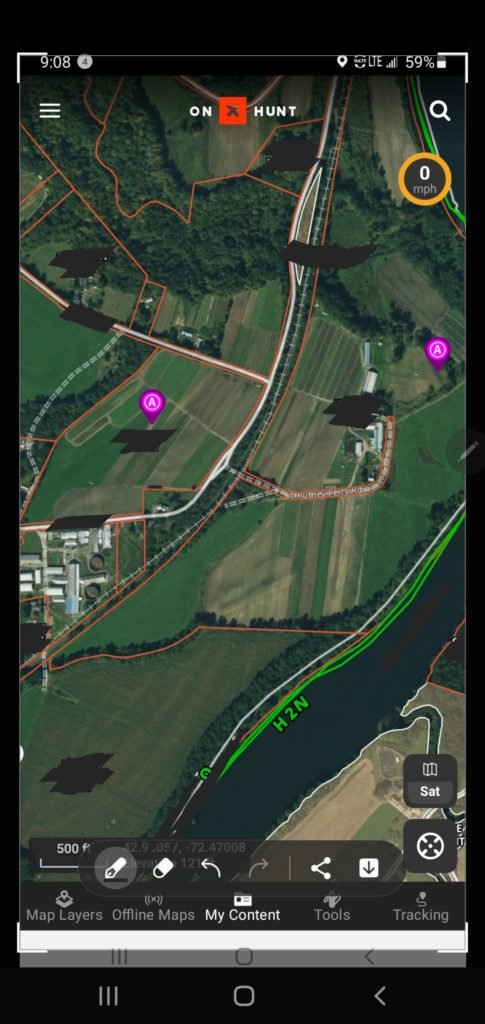
Ensuring I’m on the right ground is one of the most important features of OnX. Landowner data and property lines can be a thorn in the side of any outdoor enthusiast. My girlfriend and I started dabbling in mountain biking and I recall being run off some land that seemed like part of the trail system by an especially disgruntled farmer. For hunters and trappers, the consequences can be more severe. Even in states where permission isn’t required to access non-posted land, it’s just way better to have it. In states where permission is required for trapping, finding landowner information can be the difference between getting a permission, staying legal and having a good season, and losing your trapping license and running into conflicts with other users. Having permission also can help when addressing those discrepancies between other users. For instance, an uninformed dog walker may say: “What, you’re trapping here? You’re not supposed to be here. Is trapping even legal?” to which I can respond: “Well, actually this is private posted land that I have written permission to be on. It would appear you’re the one actually trespassing. Why don’t we reach out to the conservation officer and see how he sees things?”
Pro tips:
-Save your written permissions as images on waypoints.
-If denied a permission I mark it with a purple (A) access symbol so I don’t badger them again. Make note of the current owner so if the primo looking land changes hands you can try again with the new owner.
-With the line distance tool I use it to double check setbacks from a road or occupied dwellings when discharging a dispatch firearm.
-Remember that the landowner data is updated pretty frequently but it’s not always 100% accurate so you may need to double check things with a good old fashioned door knock.
Aerial Scouting
There’s never any shortage of work to do in the off season. Despite that, I’m often found dreaming of cooler weather and big fur checks. Planning traplines can really help mitigate those summertime blues. I’ve been toying with a road line for mink and muskrat. Onx can be a great tool for scouting lands from the comfort of your home. Say otter prices jump back up, maybe find some river bends that will likely hold cross overs and latrines. Chasing fox and coyotes? Get an idea of where the travel corridors and hard barriers are. Doing some damage control beaver work? See if you can see the lodge location from space and get an idea of where the main channel of a swamp is so you don’t go for a plunge. I like to take screenshots and draw on them when explaining estimates/proposals for control work.
Pro Tips:
-Cold rolling can be difficult. By looking at maps leading up to your trip you can often get an idea where you want to focus your setting efforts.
-In offline mode I can often find my bearing quicker than with conventional road maps.
-Use the line distance tool to see how far a haul into the woods that beaver swamp is, or how far you have to travel across the field to reach a hedge row.
-I typically use the hybrid map view, but often switch between that and the topographic one which can be easier to see streams, spring holes and tributaries.
Scouting on the Ground
Boots on the ground scouting is greatly improved by OnX. Don’t tell my insurance company, but in areas I trap I’m splitting time between the front and side window looking for sign. In areas I don’t trap I am too. You never know when you might be state hopping in the area. I drive with OnX at the ready so at a moment’s notice I tap Tools->Mark My Location. Good looking swamp…waypoint…nice square culvert…waypoint…farm that looks riddled with fox and coyote habitat….waypoint!
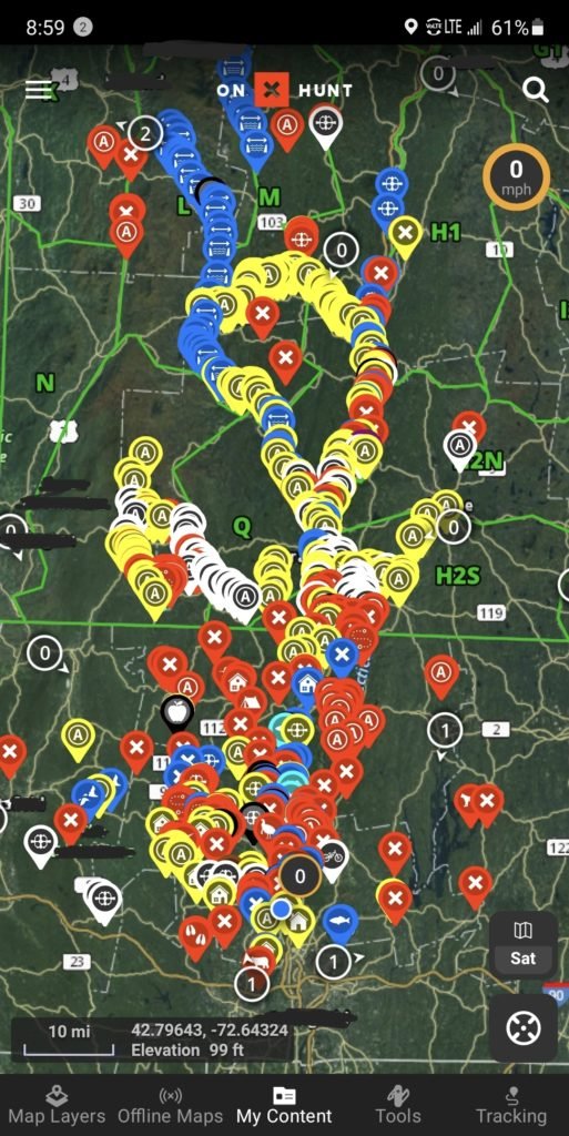
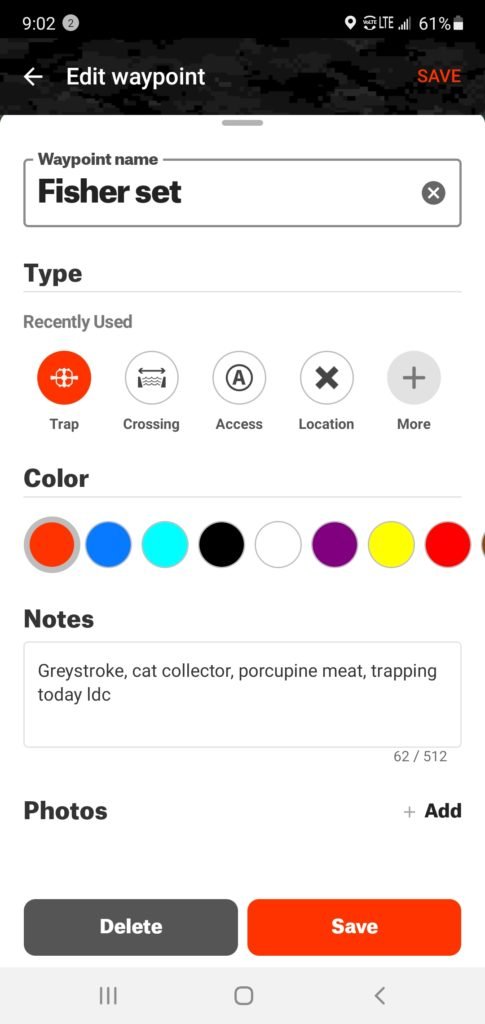
When I’m not driving I edit the specific waypoint symbol, color, and add notes. There are a ton of great symbols you can use to mark just about anything. I use one access symbol with one color for places I’d like permission and another once I have permission. Imagine before the season when digging dirt holes or trap beds and driving stakes/anchors you make a plan of exactly what you need opening day and keep track in OnX. Make notes on what sets are best for the topography, and preferred trap types. I use the Walk to Waypoint to take a look at a waypoint I may have found months or years before and it helps get me into the general vicinity.
When scouting properties, make notes of where property owners prefer you not trap so you can preserve the permission. You can add or remove map layers, so if you’re looking specifically for public land (state-owned parcels, for example), it removes some of the business of the map.
Pro Tips:
-Hit the cross hairs symbol once and it will center the map on where you are, hit it a second time and it will follow you as you’re traveling or driving (allegedly).
-Don’t be afraid to zoom in and out, add layers take away layers, or change map modes. All of these views can help you get better clarity on where you’re trapping.
-Search for landowners you have permission with and see if there are other parcels of land they own. (You’d be surprised how often they forget or fail to mention places).
On the Trapline
Someone suggested using the tracking button to prove you’re visiting all sets in the required time. This is a great tip, but hopefully not necessary in most situations. I’ve been curious about experimenting more with drags for all species, land and water. In this instance the tracking button would work great as well. Mark drag marks etc. as you grid search out. The notes section can be the perfect place to keep track of lure, bait and urine combinations at your sets. There’s enough room to keep track of check nights to catch ratios and easy to edit as well.
Downloading offline maps is quite easy and can really save you if you trap where there isn’t cell coverage. I usually download 10 or 150 mile maps (lower resolution) to make sure I don’t get lost to and from the line and then 5 mile maps (highest resolution) where I have sets. I use the trap icon and a black waypoint to indicate I actually have sets in there. If you have a large line this could help prevent forgetting to check any sets. Adding a picture of the set icon along with this could help you remember where traps are, and be invaluable if you need to have a trapping partner check your line. If your state has different seasons and bag limits in different wildlife management zones you can see those zones on OnX. (You may need to turn on that layer).
This almost belongs under the staying legal section, but I’ve often used the app to show people I am standing where I’m supposed to. Running your line differently from a different starting location, or just like to use GPS for traffic updates and detours (or speed traps)? Copy the longitude and latitude from a waypoint and plug them right into your GPS or Google Maps. Maybe you’re mentoring a newer trapper. Why not send them a couple of waypoints to help them find some success this season? Maybe you’re not a big deer hunter but your buddy is. You could trade hunting waypoints for trapping ones he comes upon.
Pro Tips:
-The wind direction indicator in OnX can be helpful in making sure your lure is blowing the right way.
-Mark any local or regional fur buyers’ locations so if you sell in the round or in the grease you can quickly see who’s closest to your current location.
-There are little pint glass icons where the local breweries are, so you can grab a cold beer after a long day of chasing fur. It should go without saying, but be responsible!
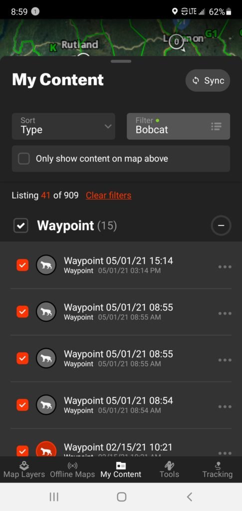
Multi-Species Longlinin’ Bonus Tip: I just discovered this while writing this article and it could be super beneficial in numerous ways. I haven’t messed with it yet, but may soon. Let’s say you’re in a state with some sort of multi-day check or you run your coyote line before work and your water line after. If you go to My Content you can hit Filter and select by type of way point and/or color. So in the example of a multi-day check, you could set a red trap icon line day one, a white trap icon line day two and a blue trap icon line day three. You can then view one line at a time so it’s not too complex. Or maybe your water waypoints are all blue and your land icons are brown. Maybe you turn off the water icons while you’re running your land line. The potential to get organized with this is pretty impressive.
Improvements
I’m an unapologetic fan of Onx. I use it for trapping, hunting, biking, foraging, trying to buy a house and so much more. With that being said, there are some things I think they could improve on.
- Give us more furbearer icons! Right now there’s only bobcat, coyote, fox, mountain lion, raccoon and wolf. It’s a good start for sure, but there could be some more added for increased organization.
- Sometimes when the “arrow” is tracking me in real time (walking or driving) it will get all bass ackwards. Not sure what that is but it’s got me a little spun around at times.
- Add a driving component. It would be amazing to plug in all my waypoints and have it direct me through my whole trap line. It’s a big ask I know. Currently in an unfamiliar area I add all my waypoints to google maps in the order that makes the most sense for the overall journey and if I lose service Google typically fares better. Then I add the location I’m currently in route to into Waze to avoid speed traps, road construction, obstructions etc.
- I wish there was something in between single state and all 50 states. For a lot of folks I think they may trap up to 3 neighboring states and the full membership can be a little steep. I dream of running all over the country so I get my all 50 state every year but it may be nice for some folks to be able to buy regional sections.
- The more I get my waypoints organized the more I see the need for more colors.
Get OnX!
OnX is an awesome company. They make some cool content have a great product. They also support trapping and Trapping Today, a pretty brave move in today’s climate. If you don’t have the funds for a paying membership there’s still a ton of free features you can use on your line. If you have the money, show them some love.
Last Tip: Don’t forget to use the code ‘TRAP’ when purchasing at onxmaps.com to get 20% off your first order, and help support us here at Trapping Today!
Leave a Reply